
*Free Shipping Over $129 - 30 Day Returns on Most Items - Most Items Ship in 1–2 Business Days

Humminbird XPLORE 10 Control Head Only


Humminbird XPLORE 10 Control Head Only
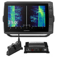
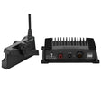
The Humminbird XPLORE 10 Control Head Only (CHO) pairs a 10-inch Full-HD display with a deep sonar and mapping feature set, making it a strong fit for anglers who plan to connect to Built-in MEGA Imaging on a Minn Kota trolling motor, add a MEGA 360 Imaging transducer, or tap into an existing Humminbird Ethernet sonar network. The unit ships with both LakeMaster and CoastMaster map cards covering 13 regions across the United States and Canada — a distinction unique to the XPLORE Series — and supports Wi-Fi, Bluetooth, NMEA 2000, and Ethernet for full One-Boat Network compatibility.
Specifications:
- Control Head Only — no transducer included; compatible with Built-in MEGA Imaging Minn Kota trolling motors, MEGA 360 Imaging accessory transducers, and Humminbird Ethernet sonar sharing
- 10-inch Full-HD ultra-clear display, 1280H x 720V resolution
- Cross Touch interface — operated via touchscreen or directional keypad
- Dual Spectrum CHIRP Sonar (requires optional transducer): Wide Mode for maximum coverage and Narrow Mode for fine detail; powered by Low-Q CHIRP transducer technology
- MEGA Side Imaging+ (requires optional transducer): side-scanning coverage up to 200 feet on each side of the boat; 20% more detail and 60% more range than standard MEGA Side Imaging
- MEGA Down Imaging+ (requires optional transducer): downward coverage to 200 feet; 20% more detail and 60% more depth capability than standard MEGA Down Imaging
- MEGA Imaging+ total coverage: up to 250 feet below and out to either side of the boat
- 2D Dual Spectrum CHIRP sonar with superior target separation and fish arch clarity
- Internal GPS with Humminbird Basemap — includes charts of more than 10,000 lakes plus coastal coverage for the continental U.S.; displays buoys, day markers, hazards, marinas, contours, and depth markers
- Includes Humminbird LakeMaster and CoastMaster mapping cards with North American standard data (13 U.S. and Canada regions) — exclusive to the XPLORE Series
- Compatible with optional Navionics charts and additional LakeMaster and CoastMaster premium chart options
- Wi-Fi, Bluetooth, NMEA 2000, and Ethernet networking
- One-Boat Network compatible — works with Humminbird, Minn Kota, and Cannon products