

Table of Contents
- Why Marking Fishing Hotspots on Marine GPS Matters
- Step-by-Step: How to Mark a Location on Your Sonar Screen
- Visual Triangulation Techniques for Pinpoint Accuracy
- The Best Marine GPS for Fishing: What to Look For
- How to Organize Waypoints on Garmin: Naming, Editing, and Deleting
- Mobile Apps, Syncing, and Post-Trip Analysis
- Conclusion: Build a Reliable Hotspot Database
- Frequently Asked Questions
Last Updated: September 22, 2026
Why Marking Fishing Hotspots on Marine GPS Matters
The difference between a good day and a great day on the water often comes down to one thing: whether you can mark fishing hotspots well enough to find that spot again. Learning how to mark fishing hotspots on marine GPS turns a lucky catch into a repeatable pattern. At Elliott's Tackle & Rigging, we've watched too many anglers hook into a limit of king salmon or a pile of halibut, only to spend the next weekend hunting the same piece of structure from memory.
That's a losing game.
Step-by-Step: How to Mark a Location on Your Sonar Screen
Marking a spot takes about three seconds once you know the buttons. The mistake is doing it too late, after the fish have moved and your boat has drifted off the structure.
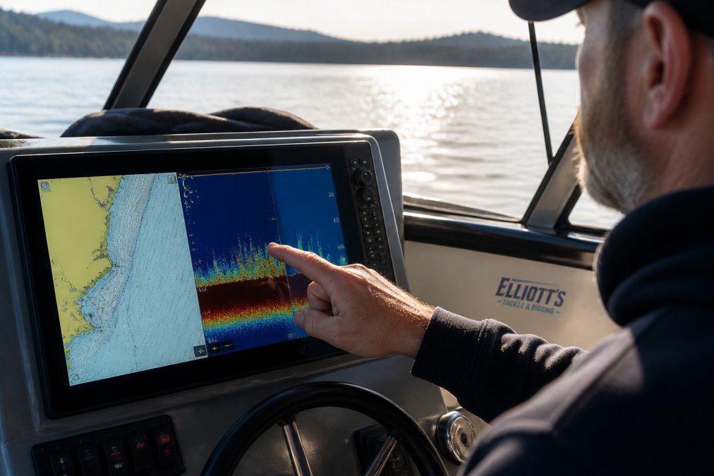
Here's the process on most modern combo units:
- Watch your sonar screen and chartplotter together. Fish arches and bottom contour tell you where the structure sits.
- The moment you see what you want (a bait ball, a ledge, a wreck), hit the Mark or Waypoint button.
- Confirm the save on screen. Most units auto-name it with a number.
- Rename it later at the dock. Don't skip this step.
Using Cross-Hair Cursors for Precision
The cross-hair cursor is the most underused tool on any chartplotter. Instead of marking your boat's position, you move the cross-hair over the exact spot on the chart and save that. This matters when you spot a rock pile 40 feet off your starboard bow. Mark the rock, not the boat.
Marking While Trolling: Best Practices
Trolling complicates everything because you're moving. A common mistake is marking where the rod goes off, not where the fish actually is. Remember your setback: if you're running 80 feet of line behind a downrigger, the fish is well behind your transom. Mark ahead of the strike, not on top of it.
Visual Triangulation Techniques for Pinpoint Accuracy
Triangulation is how you lock a spot down when GPS alone feels too loose. The idea is simple: line up two or more fixed visual references on shore, then save the waypoint where those lines cross. The execution is where most anglers get sloppy.
Picking References That Actually Work
Not every landmark makes a good reference. You want objects that are:
- Fixed, a water tower, a church steeple, a specific point on a bluff, a channel marker, a radio tower. Not a moored boat or a tree that could fall.
- Distinct, something you can identify from a mile away without squinting. A single pine tree on a uniform ridge is better than "the treeline."
- Spread apart, two references close together give you a narrow angle and a sloppy fix. Aim for at least 45 degrees between your sight lines.
The Two-Line Method in Practice
Say you're fishing a reef off the coast. You line up a water tower with a specific notch on a bluff to your north. You note a second alignment with a red channel marker and a radio tower to your south. Where those two sight lines cross is your spot.
Why Bother When GPS Is Accurate to a Few Feet
Three reasons:
- GPS drifts. Selective availability is gone, but multipath, ionospheric interference, and a weak fix near cliffs can still push you 10 to 30 feet off. On a small rock pile, that is the difference between fishing it and missing it.
- Visual confirmation beats a number. When your chartplotter is zoomed out to show a whole bay, a waypoint dot is a guess. A lined-up water tower is a fact.
- It works when electronics fail. A dead battery or a wet connector does not erase a shoreline you have memorized.
Adjusting for Depth, Current, and Drift
Triangulation is not static. On a fast outgoing tide, your boat drifts while you are lining up references. Mark the spot on the chart where the sight lines cross, not where your bow is pointing. In deep water, small angle errors translate to big position errors, a one-degree mistake at 300 feet of depth can put you 15 feet off the structure. Shallow flats are more forgiving.
The Best Marine GPS for Fishing: What to Look For
The best marine GPS for fishing is the one that lets you mark, name, and find spots without fighting the interface. Screen size, sonar compatibility, and networking matter more than brand loyalty.
| Feature | Why It Matters | What to Look For |
|---|---|---|
| Screen size and brightness | You read it in direct sun | 10-inch or larger, sunlight-viewable |
| Sonar compatibility | Structure ID drives your marks | CHIRP, SideVü, LiveScope support |
| Waypoint capacity | You'll save hundreds | Thousands, with easy naming |
| Networking | Ties into radar, autopilot | NMEA 2000 and Marine Network |
| Touchscreen vs. keypad | Speed of marking | Touchscreen plus physical buttons |
How to Organize Waypoints on Garmin: Naming, Editing, and Deleting
Learning how to organize waypoints on Garmin comes down to one habit: name them the moment you save them. A list of 400 waypoints called "001" through "400" is worthless by August.
A naming system that works:
- Species first: KING, HALI, LING, WALLEYE
- Structure type: REEF, LEDGE, WRECK, FLAT
- Depth in feet: 120, 240, 60
- Example: KING-REEF-120
Mobile Apps, Syncing, and Post-Trip Analysis
Mobile apps changed how anglers manage spots, but most guides stop at "download the app." The real value is in how data moves between your phone, your chartplotter, and your home computer, and how you keep that data private.
How Syncing Actually Works
On Garmin units, the ActiveCaptain app pairs over Wi-Fi with a compatible chartplotter. Once paired, waypoints, routes, and tracks transfer both directions. Mark a king salmon spot on the water, and it lands on your phone before you hit the ramp. Plot a route at home, and it shows up on your chartplotter when you power up.
Garmin GPSMAP® 8610xsv Combo →
Moving Marks Between Brands
The hard part is cross-brand transfer. A Garmin waypoint file (GPX) will import into a Raymarine unit and vice versa, but only if you export it correctly. The workflow:
- Export waypoints from your unit to a microSD card as a GPX file.
- Open the file on a computer and check for naming errors or duplicate coordinates.
- Import the GPX file into the new unit through its card slot.
- Verify a handful of marks on the chart before you trust the whole list.
Post-Trip Analysis That Builds a Season Strategy
After each trip, review your marks before you forget the conditions. Log four things for every waypoint that produced:
- Depth in feet
- Water temperature
- Tide stage or current direction
- Time of day
Protecting Your Secret Spots
- Do not share your unit's Wi-Fi password with casual acquaintances at the dock. Anyone paired to your chartplotter can pull your full waypoint list.
- Strip waypoints before selling a unit. Factory reset does not always wipe user data. Delete waypoints manually, then reset.
- Be careful with community apps. Some apps upload your marks to a shared database by default. Check the privacy settings before you sync.
- Use private lists. Most modern units let you group waypoints into lists that stay local and do not sync to cloud services.
Pair your phone workflow with a unit that handles the transfer cleanly. The Garmin GPSMAP 8612xsv supports ActiveCaptain syncing and GPX import/export, so your marks move between phone, unit, and computer without a fight.

Conclusion: Build a Reliable Hotspot Database
The anglers who consistently find fish aren't lucky. They've built a database of marks, named them clearly, and reviewed what worked. Marking fishing hotspots on marine GPS is the foundation of that system.
Frequently Asked Questions
How do I mark a waypoint on my marine GPS while trolling?
When trolling, you can't stop to fiddle with menus. Use a dedicated waypoint button if your unit has one, like the oversized waypoint key on the Raymarine Element 12 HV. If not, set up a quick-access shortcut. As soon as you see fish or structure on the sonar, press the button to drop a mark. You can rename and refine the coordinates later. This keeps your lines in the water and your spot saved.
Can I import fishing hotspots from a mobile app to my chartplotter?
Yes, many modern chartplotters support syncing via mobile apps. For example, the Garmin GPSMAP 8610xsv is compatible with the ActiveCaptain app for trip planning and prefishing. You can mark spots on your phone's map, then sync them to your unit. Check that your chartplotter has Wi-Fi or ANT connectivity and that the app supports waypoint transfer. This lets you scout from the couch and hit the water running.
What is the best way to organize fishing waypoints for different species?
Use a consistent naming system that includes species, structure type, and date. For example, 'KingSalmon-DeepLedge-0526'. Group waypoints by species or area using folders or lists if your unit supports it. On Garmin units, you can use symbols and colors to differentiate. The goal is to find the right spot fast. If you're targeting halibut, you don't want to scroll through a hundred salmon marks. A little organization saves time on the water.
How do I use sonar history to mark a spot I already passed?
Sonar history lets you scroll back to see what you missed. On most units, pause the sonar and use the cursor to scroll back through the water column. When you find the structure or fish arch, place the cursor on it and press the waypoint key. The GPS will mark the coordinates where that target was. This is especially useful for trolling passes where you can't turn around immediately. You can mark it now and return later.
0 comments